Geology
"Physical geography and geology are inseparable scientific twins" ~Roderick Impey
Isle Royale was made by fire and ice. Glacial ice retreated 10,000 years ago and Isle Royale rose above what would become Lake Superior. It was created by a fold in the rock layers. One end of the fold is the isle and the other end is the Keweenaw peninsula. One major bedrock formation on the island is Portage Lake Lava, this covers 85% of the island. Another major bedrock formation is Copper Harbor Conglomerates, this makes up 15% of the island. Both of the major bedrock formations were modified by 4 glacial periods, the last one was just 12,000 years ago. It altered the ridges and valleys, leaving a thin (a few inches to 4 feet) mantle of glacial deposits. The thinnest deposits are near the Lake Superior shoreline.
There is also many lakes on Isle Royale. These were created because as glaciers retreated from the Lake Superior Basin, water melting created the lakes. Around Fedtmann lake, Grace Harbor and Siskiwitt River Basin are wave cut terraces, beach ridges, and barrier bars. These are all evidence of lake levels and their created landforms.
Soils are also a very important part of Isle Royale. They are impacted by bedrock, climate, vegetation, chemical changes, time, activities of decomposers, changing lake levels, and deposition of soil by wind. Lowland soils take up 20% of the island, they're 4 feet in depth and poorly drained, they formed from either woody of herbaceous vegetation. Most soil deposits on the island is upland soil. It is well drained on ridges. The soil is deeper on the south slopes and shallower on the north slopes. Isle Royale is overall pretty low in elevation, but it has many cool physical features and formations to see while visiting.
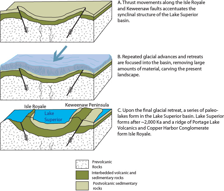
How Isle Royale was formed
